• Facebook
  • Pinterest
  • Instagram
  • YouTube
  • LinkedIn
  • Skip to secondary menu
  • Skip to main content
  • Skip to primary sidebar
  • Skip to footer

Tina's Dynamic Homeschool Plus

Activity, Change, Progress

  • HOME
  • How to
    • Preschool
    • Kindergarten
    • Elementary
      • Geronimo Stilton Books
    • Middle School
    • High School
      • Science 
  • Planner
  • Lapbooks
    • Trioramas
    • History Games
    • LEGO
  • Shop
  • GET STARTED NOW!
    • Learning Styles
  • 7 Step Planner
    • Free Student Planner
    • Free Home Binder
  • Unit Studies
    • Creation to Ancients
      • Mesopotamia
    • Middle Ages to Reform
    • Exploring to Revolution
    • World Wars to Today
    • Science
  • Curriculum
    • More Unit Studies
    • Geography
    • Writing PreK to 12th
    • Free Art Curriculum
  • BootCamp
    • Resources
      • Ultimate Unit Study Planner

1. My FREE Learning Printables {Any Topic}

How to Memorize the Countries of South America & Mountain Climate Zones Minibooks

October 3, 2013 | Leave a Comment
This post may contain affiliate links. For more information, please see my full disclosure policy.

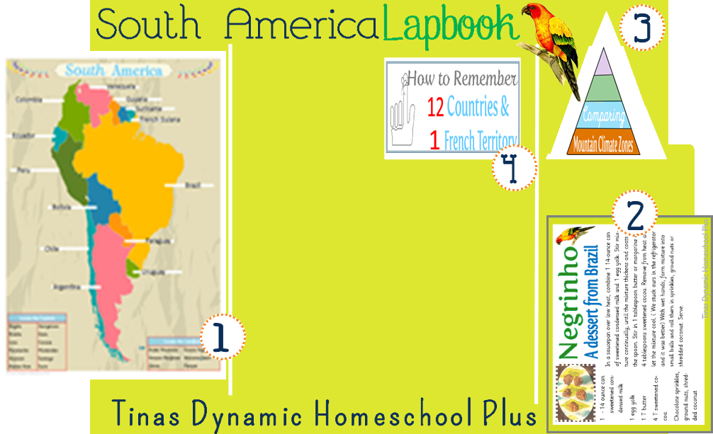
South America LapbookI went ahead and started planning and arranging the minibooks, that we have so far,  on a file folder for our South America Unit Study. Remember these can be glued notebook style too. Nothing babyish about lapbooking or notebooking.

We still don’t glue them in our file folder at this point, this is just a visual so I know where else to place the upcoming minibooks too. We are up to 4 now.

Today, I have minibooks 3 and 4 for you.

Comparing Mountain Zones - Andes @ Tina's Dynamic Homeschool PlusMinibook 3 is Comparing Mountain Climate Zones. It is a book I prepared because I wanted us to focus on the climate of the Andes Mountain and compare them for our geography niche on this.

Near the equator the climate at the lowest elevation is tropical. If you were to climb midway up the mountains, you would find a more mild climate and then again at 15,000 feet you would find extremely low temperatures and icy winds.

Facts to Learn About South America

Notice on the book, the cover has 4 different colors so this is a visual to match the accordion fold minibook so that your child understands about each zone. The top part or light purple is the Tierra Helada and the light green is Tierra Fria and etc.

So here are the facts for using in the minibook. I probably should do an answer key to go with the book, but this information really finds it way to my website. So I just add it here for you in case you and the kids want to go ahead and do it.

Frozen Land or Tierra Helada .

  • Above 10,000 feet
  • Place for livestock like llamas and sheep

Cold Land or Tierra Fria

  • 6,000 – 10,000 feet
  • Place for crops: Wheat, apples, potatoes and barley

Temperate Land or Tierra Templada

  • 3,000 – 6,000 feet
  • Place for crops: corn, cotton, coffee and citrus fruits

Hot Land or Tierra Caliente

  • Sea Level – 3,000 feet
  • Place for crops: bananas, cacao, sugar cane and rice.

How to Remember the Countries of South America

Memorize the Countries of South America at Tina's Dynamic Homeschool Plus

Minibook 4 is a book that uses a mnemonic saying to remember the 12 countries and the one 1 French territory. Give me something that doesn’t make sense anytime to remember and that is what I will remember.

Too, help your child to understand that French Guiana is a territory like a state is here to us in the United States. If you don’t live here, then use one of your local provinces to describe a dependent area so they understand that it is not a country.

This came from a neat website called Memorize the World. Here is how it goes: The Biggest Country (Brazil). Arnie Takes his mom Tina to eat Chile. (Argentina and Chile). Cool Vegetable Guy Studies French (Colombia, Venezuela, Guyana, Suriname and French Guiana).  Every Person Boils Purple Unicorns. (Ecuador, Peru, Bolivar, Paraguay and Uruguay.) That’s it.

Project and Study Ideas for South America

To flesh out this unit some more, here are more ideas for each subject. There is NO shortage of content or ideas to spur your sparks of creativity. Unit studies have this affect on us.

How to Memorize the Countries of South America & Mountain Climate Zones Minibooks

Nazca Lines – The Monkey

How to Memorize the Countries of South America & Mountain Climate Zones Minibooks

Nazca Lines – The Dog (Pic Attribution)

History

Nazca is the name of the culture that flourished in Peru and also the name of the mysterious lines they created in the Peruvian deserts. These lines, carved into the desert rocks depict huge animals and geometric shapes. No one is really certain about what they mean.

Also, compare and contrast Inca society to Spanish colonial society.

Science

Research the Galapagos Islands and the animals unique to that region.

Math

Why did Ecuador change its currency from sucres to dollars? Also understand some about the metric system since its used there.

Geography

1.  Create a travel brochure and map to show what journey you would take if you visited South America. Compare and contrast animals and plants living in the different mountain zones.

2. Also list some of the famous places like Machu Picchu in Peru. Indians build that walled city and for hundreds of years it was hidden from the rest of the world.

3. Famous places.  People go to see the Gold Museum in Bogota, Colombia and there are emerald mines nearby too.

4. Quito is one of the highest cities in the world and it in Ecuador. It sits on the side of a volcano and is the oldest capital city in South America.

5. Make a map of South America and focus on the major regions: Andes, Amazon Basin, Guiana Highlands, Orinoco Basin, Rio de la Plata Complex, Brazilian Plateau, Pampas, Patagonia, Llanos, Pantanal, Wet Coast Flatlands, Southern Chile coast and color each a different color or make it different colors using salt dough.

Art

Find examples of the art of Manuel Rendon, Eduardo Kingman and Juan Agustin Guerrero.

Music

Research flutes played by native people from Ecuador. Listen to or watch an Argentinean tango, a Brazilian samba and a Colombia cumbia.

Did I tell you that I grew up dancing the cumbia? BELIEVE me, coordination and grace are not at the top of my skill set, but this dance is so easy and fun.

Look at a few of these videos.  I love the first one because you can actually hear the music and watch the partner steps and the second one shows basic steps with no music.

Food

How to Memorize the Countries of South America & Mountain Climate Zones Minibooks

Make Fried Plantain

Colombians often eat plantains in place of potatoes.

How to Memorize the Countries of South America & Mountain Climate Zones Minibooks

(Cesar Vellejo)

Language/Language Arts

1. Cesar Vallego (1892-1938) one of the greatest twentieth century poets focused on poverty and injustice. Study his poems and his life.

2. Learn some Spanish

si  = yes

por favor = please

gracias – thank you

de nada – you’re welcome

buenos dias = good morning

adios = good – bye

ayer = yesterday

hoy = today

manana = tomorrow

Como esta usted? = How are you?

muy bien = very well

Donde esta…..? =  Where is…?

How to Memorize the Countries of South America & Mountain Climate Zones Minibooks

(quipu. Pic. Attribution)

3. Do some Inca Writing. Find a picture of a quipu, the knotted cotton cords of different lengths and colors with which Incas kept records. Using thick yarn, try to imitate the pattern.

I think we need some vocabulary words and we are going to focus next on some of the animals of the Galapagos.

South America Printable Minibooks

Also, look at these minibooks which come in the free South America lapbook 27 page download.

  • Animals of the Galapagos fan book which includes the Giant Tortoise, Lava Lizard, Marine Iguana, Green Turtle, Galapagos Penguins, Magnificent Frigate Bird, Blue-Footed Booby, and Blue-Banded Goby.
  • Comparing Mountain Climate Zones
  • Simon Bolivar Copywork
  • Map of South America to label and one labeled
  • Machu Picchu – Lost City of the Inca
  • Negrinho – A dessert from Brazil
  • How to Memorize the Countries of South America and Dependent
  • Map Flags to put on your salt dough map
  • 2 – The Galapagos Island layered book. One prefilled with facts and one blank to add your own information.
  • Vocabulary Pocket and Vocabulary Words

More South America Unit Study Resources

  • Appreciating the Culture of South America Through Dance
  • Free Machu Picchu Mini Book & Completed South America Lapbook
  • 6 South America Country Notebooking Pages
  • South America Unit Study– Colorful Free Printable Map
  • South America Geography Salt Dough Map + Printable Pennants
  • South America Unit Study resources

How to Get the Free South America Printable Lapbook

Now, how to grab the free lapbook. This is a subscriber freebie.

That means when you sign up to follow me, you get access to my subscribers library and this freebie.

However, not all my freebies are in the library (wink).

I like to keep up to date with what is valuable to you so I can give you more, some freebies you must sign up again on the form below even if you are already a follower.

And it’s the only way I have of freely delivering them to you. Just follow the steps below.

► 1) Sign up on my list.
► 2) Go to your inbox and confirm your email from the automatic reply I sent you. If you’re already a confirmed subscriber, you will not have to do this. You’ll receive the freebie instantly.
 ►3) Last step. look for my reply AFTER you’ve confirmed your email.

Ocean Currents and The Galapagos1

Leave a CommentFiled Under: 1. My FREE Learning Printables {Any Topic}, Geography Based, My Unit Studies {Free Printables & Hands-on Ideas}, Science Based Tagged With: hands on history, hands-on, hands-on activities, south america

South America Unit Study– Colorful Free Printable Map

September 16, 2013 | 4 Comments
This post may contain affiliate links. For more information, please see my full disclosure policy.

I just wanted to remind you before I move on with our unit study that my site now has over 30 lapbooks.

south america unit study

Now that I got Monday morning business out of the way, I wanted to share the next part to our South America unit study that we are on right now, which is a map.

We have just been using our atlases and books from the library on this unit study and started off by locating the countries and landforms of South America.

Label Map of South American Countries @ Tina's Dynamic Homeschool Plus

South America Colorful Map

We love doing the salt dough map, but this paper printable map I created also gives us a place to jot down other landforms, the capitals and even natural resources. Plus, we can stick this baby in our lapbook to come back and study too.

I have 2 maps or choices like I always try to do.

One is labeled with the countries for our sweet little ones that can’t write yet and sweet big ones that don’t want to ..tee hee hee (Ok, sometimes you just don’t need tons of writing to try to make it fun) and then I have one that is not labeled, which is the one pictured above. As always, you decide what is best for your brood.

I have some websites and key vocabulary words and of course some more ideas for hands-on coming up on this unit study too.

It’s been too long since I have shared an inspirational quote. I received a book, a  gift from a dear homeschooling mom which has 365 quotes in it and I read one quickly every morning. It like a mini-energy vitamin for the day because it sets my mind on fire. Here is one I heart today:

Over 30 Free Unit Studies and growing @ Tina's Dynamic Homeschool Plus

“If you want to succeed you should strike out on new paths, rather than travel the worn paths of accepted success.”

John D. Rockefeller

So true! Isn’t that what we are doing today?

South America Unit Study– Colorful Free Printable Map

South America Printable Minibooks

Also, look at these minibooks which come in the free South America lapbook 27 page download.

  • Animals of the Galapagos fan book which includes the Giant Tortoise, Lava Lizard, Marine Iguana, Green Turtle, Galapagos Penguins, Magnificent Frigate Bird, Blue-Footed Booby, and Blue-Banded Goby.
  • Comparing Mountain Climate Zones
  • Simon Bolivar Copywork
  • Map of South America to label and one labeled
  • Machu Picchu – Lost City of the Inca
  • Negrinho – A dessert from Brazil
  • How to Memorize the Countries of South America and Dependent
  • Map Flags to put on your salt dough map
  • 2 – The Galapagos Island layered book. One prefilled with facts and one blank to add your own information.
  • Vocabulary Pocket and Vocabulary Words

More South America Unit Study Resources

  • Appreciating the Culture of South America Through Dance
  • Free Machu Picchu Mini Book & Completed South America Lapbook
  • 6 South America Country Notebooking Pages
  • How to Memorize the Countries of South America & Mountain Climate Zones Minibooks
  • South America Unit Study– Colorful Free Printable Map
  • South America Geography Salt Dough Map + Printable Pennants
  • South America Unit Study resources

How to Get the Free South America Printable Lapbook

Now, how to grab the free lapbook. This is a subscriber freebie.

That means when you sign up to follow me, you get access to my subscribers library and this freebie.

However, not all my freebies are in the library (wink).

I like to keep up to date with what is valuable to you so I can give you more, some freebies you must sign up again on the form below even if you are already a follower.

And it’s the only way I have of freely delivering them to you. Just follow the steps below.

► 1) Sign up on my list.
► 2) Go to your inbox and confirm your email from the automatic reply I sent you. If you’re already a confirmed subscriber, you will not have to do this. You’ll receive the freebie instantly.
 ►3) Last step. look for my reply AFTER you’ve confirmed your email.

Ocean Currents and The Galapagos1

4 CommentsFiled Under: 1. My FREE Learning Printables {Any Topic}, Geography Based, History Based, My Unit Studies {Free Printables & Hands-on Ideas}, Science Based Tagged With: map, south america

South America Geography Salt Dough Map + Printable Pennants

September 8, 2013 | 19 Comments
This post may contain affiliate links. For more information, please see my full disclosure policy.


Tiny never gets his fill of doing something fun and hands-on when we start  a geography unit. We did a salt dough map in our Arctic & Inuit Unit Study and he remembered and ask for it again to start our South America Unit Study. Too, look at my page Homeschool Geography for hands-on and simple ideas and tips.

Why mess with something working? Besides after you make it, you can use it again and again as review during the unit study. It’s so much more fascinating and interactive than a worksheet too.

Before I forget though I want to update the salt dough recipe I had used before because it was wayyy too much. So I cut it in half this time and still had plenty left over.

We tend to use left over pizza box lids as our platform and unless you are going to make your salt dough map giganto, you should be fine with this new recipe. Of course, you can double it if you need more.

South America Geography Salt Dough Map + Printable Pennants

So here is the update recipe for you which is all the ingredients cut in half. If you want to see how we create it, look at my post on the Arctic & Inuit Unit Study.

South America Geography Salt Dough Map + Printable Pennants


Also, a really good map is needed and we had a big map that pulled out of the center of our atlas. This was really way more helpful than just printing one off the internet.

South America Geography Salt Dough Map + Printable Pennants

Since we are working on identifying more of the landforms, we wanted to draw those in and so Tiny use the most complicated tools

South America Geography Salt Dough Map + Printable Pennants

—like a toothpick and plastic clay roller —to draw in the political boundaries of each country.  Simple I am telling you, so simple to keep it fun.

Remember you have to draw in your land forms and place a toothpick in the holes before it dries overnight.

South America Geography Salt Dough Map + Printable Pennants

We also took time to look at the Amazon and some of it’s tributaries and used the toothpick to draw it going through Brazil (top right) and he formed the Galapagos Islands on the left side.

Tiny only put one island there though there are many islands that Charles Darwin investigated. Of course this is why it’s important that he learn to use the map to see that the Galapagos are made up of many islands and not just one.

Then next we went about locating the Andes mountain range.

South America Geography Salt Dough Map + Printable Pennants

He had the idea of forming little peaks or mountains down the left side to show the stretch of the Andes mountains.  I think they turned out so cute, but he was disappointed. Tiny is like Mr. Senior 2013, he has a high standard for his work and expects perfection. I just expect fun.

Of course after he painted the peaks brown they did look like chocolate kisses which gave me another idea.  This map could be made out of sugar cookie dough and use chocolate Hershey kisses for the mountains. Use frosting to decorate each country and make this edible.

South America Geography Salt Dough Map + Printable Pennants

Then because we are working on identifying/locating all the countries and one French territory, and Galapagos Islands, I created some country flags or pennants. Not only that, but by him painting each country a separate color, it really has helped to identify each one, which is another objective of mine.

South America Geography Salt Dough Map + Printable Pennants

Lastly, he labeled it and added in the equator and showed it running through Ecuador, which in Spanish means “equator”. We still need to add in the Tropic of Capricorn.

South America Geography Salt Dough Map + Printable Pennants

Tiny has loved doing these maps each time and it is a great way to bring geography and history alive. I guess you can say we never tire of hands-on geography and fun sets the tone for learning.

More to come as we trek our way through South America.

South America Printable Minibooks

Also, look at these minibooks which come in the free South America lapbook 27 page download.

  • Animals of the Galapagos fan book which includes the Giant Tortoise, Lava Lizard, Marine Iguana, Green Turtle, Galapagos Penguins, Magnificent Frigate Bird, Blue-Footed Booby, and Blue-Banded Goby.
  • Comparing Mountain Climate Zones
  • Simon Bolivar Copywork
  • Map of South America to label and one labeled
  • Machu Picchu – Lost City of the Inca
  • Negrinho – A dessert from Brazil
  • How to Memorize the Countries of South America and Dependent
  • Map Flags to put on your salt dough map
  • 2 – The Galapagos Island layered book. One prefilled with facts and one blank to add your own information.
  • Vocabulary Pocket and Vocabulary Words

More South America Unit Study Resources

  • Appreciating the Culture of South America Through Dance
  • Free Machu Picchu Mini Book & Completed South America Lapbook
  • 6 South America Country Notebooking Pages
  • How to Memorize the Countries of South America & Mountain Climate Zones Minibooks
  • South America Unit Study– Colorful Free Printable Map
  • South America Geography Salt Dough Map + Printable Pennants
  • South America Unit Study resources

How to Get the Free South America Printable Lapbook

Now, how to grab the free lapbook. This is a subscriber freebie.

That means when you sign up to follow me, you get access to my subscribers library and this freebie.

However, not all my freebies are in the library (wink).

I like to keep up to date with what is valuable to you so I can give you more, some freebies you must sign up again on the form below even if you are already a follower.

And it’s the only way I have of freely delivering them to you. Just follow the steps below.

► 1) Sign up on my list.
► 2) Go to your inbox and confirm your email from the automatic reply I sent you. If you’re already a confirmed subscriber, you will not have to do this. You’ll receive the freebie instantly.
 ►3) Last step. look for my reply AFTER you’ve confirmed your email.

Ocean Currents and The Galapagos1

19 CommentsFiled Under: 1. My FREE Learning Printables {Any Topic}, Geography, Geography Based, Hands-On Activities, My Unit Studies {Free Printables & Hands-on Ideas}, Science Based Tagged With: hands on history, hands-on activities, handson, salt dough map, south america

Ancient Civilization Unit Ancient Greece Ancient Rome Free Minibooks

June 30, 2013 | 2 Comments
This post may contain affiliate links. For more information, please see my full disclosure policy.

I am finishing up the last of the minibooks for our Ancient Civilization Unit. Also, look at my page Homeschool Lapbooks – Powerful Tools For Mastery Learning for more free lapbooks.

My goal in doing this unit study was to quickly cover some of the ancients and get Tiny familiar with them.

When I first started the 4 year history cycle with my older boys, I found that I covered a wide variety of topics . Now I prefer to cover less topics,  but in more depth.

As much as I love our study of history I have accepted the fact that it really is just a few short 12 years you have to cover any subject. There is just no way you can cover all that you like or want to.

Ancient Civilizations Unit and Lapbook

Also though because we have covered a lot of Ancient Greece and Ancient Rome, I decided it would be better for Tiny to know a few names.

So I have a mini fact card for Plato for Ancient Greece and a mini fact card for Caesar Augustus when studying Ancient Rome.

Minibooks 7 and 8 are ready for download. There is a pocket for each fact card and they are glued on the right flap.

You know I told you back about a month ago when the boys made the Celtic cakes that for some reason they were so enamored with them that they chose to put that as their last minibook in the lapbook.  You can add that too or include some other hands-on activity that you like.

Here are the prior lapbooks we did for Ancient Greece and Ancient Rome that round out this unit study.

Seeing the need to cover some subjects a little faster so you don’t lose the momentum through the years, I am so excited about our present study using the curriculum from BrimWood Press

We got interrupted on our study when hubby had his procedures, but we are getting ready to get back on it.

The main thing I am giddy about is that how in a short time you can cover so much. From the site: “ In fourteen lessons, What Every Child Needs to Know about Western Civilization builds a mental timeline of 5,000 years of history and an understanding of the historical contributions that shaped Western Civilization. This guide and its literature companion Calendar Quest will revolutionize the way children learn history. “

Western Civilization Study by Brimwood Press

I am almost  finished with it and will be doing a review on it, but have fallen in love with the fact that you don’t have to take a whole year to cover one era in history.

You now have all the printables for the Ancient Civilization Unit. I will be sharing a few more hands-on things we liked for this unit too.

Update: This lapbook is now complete!

HOW TO GET THE FREE ANCIENT CIVILIZATIONS II LAPBOOK

Now, how to grab the freebie. It’s a subscriber freebie.

1) CLICK HERE ON THIS LINK TO SIGN UP ON MY EMAIL LIST & TO GET THIS FREEBIE.

2) Grab the freebie instantly.

3) Last, look for all my emails in your inbox. Glad to have you following me

2 CommentsFiled Under: 1. My FREE Learning Printables {Any Topic}, History Based, My Unit Studies {Free Printables & Hands-on Ideas} Tagged With: ancient civilizations, lapbook

Ancient Phoenicia MinibookModern Day Lebanon

June 16, 2013 | 3 Comments
This post may contain affiliate links. For more information, please see my full disclosure policy.

The Phoenicians were famous seaman and founded colonies all over the Mediterranean Sea. When we studied the ancients this time, I tried to focus on making it matter by tying it to its modern day location which is Lebanon. 

Though the boys enjoyed reading about Beirut and understanding that Beirut is the capital of Lebanon, I think they enjoyed it a little more when we made the glass blowing connection. After we studied it last time, we focused on the Phoenicians craft of glass making.

Because I like to keep my units with some hands-on activities, I collected a few activities about Ancient Phoenicia at the bottom of this post.  That way we both have some resources when we review this again.

Phoenicians Ancient Civilization

Today, I also have the next minibook on Ancient Phoenicia. It is a tab book and I have a map included in this download that glues on the inside and a few facts too if you want to use them.

Ancient Civilization Lapbook

It is book 6 and it goes placed at the top right side.  We did revisit our glass blowing lapbook to make it somewhat hands-on.

Ancient Phoenicia Craft Roundup

I rounded up a few other hands-on ideas because it really makes learning about any topic a bit more lively. Even something simple is more memorable than a worksheet.

img_3614
img_35111
1008-projects-003

Look at this fun boat made by the kids at Creekside Learning..They also made purple dye. Pic. Att: Satori Smiles) Over at Satori Smiles they used an expired bag of frozen blueberries to make the dye.

Glass Blowing Lapbook

My glass blowing lapbook ties in with this unit too. Click here to go there.

phoenician464
Lovelearnplay
Ancient Phoenicia MinibookModern Day Lebanon

The Phoenician alphabet. I could see making a code of some sort to make this more interactive.

The Artful Parent has some beautiful ideas for doing some glass activities that would make studying this topic take an art trail. Click here to go there.

Then some links we marked/found helpful.

  • Reviews & Quizzes for Story of the World Volume 1. A helpful resource that has multiple questions to use for review and that is interactive.
  • History of the Phoenicians
  • Quizlet has some flashcards.

I hope some of these ideas help to spark your creative ideas or add to enrich your study about the Ancient Phoenicians.

HOW TO GET THE ANCIENT CIVILIZATIONS II LAPBOOK

Now, how to grab the freebie. It’s a subscriber freebie.

1) CLICK HERE ON THIS LINK TO SIGN UP ON MY EMAIL LIST & TO GET THIS FREEBIE.

2) Grab the freebie instantly.

3) Last, look for all my emails in your inbox. Glad to have you following me!

3 CommentsFiled Under: 1. My FREE Learning Printables {Any Topic}, Ancient Civilizations, Hands-On Activities, History Based, History Resources, My Unit Studies {Free Printables & Hands-on Ideas} Tagged With: hands on history, homeschool

  • « Go to Previous Page
  • Page 1
  • Interim pages omitted …
  • Page 24
  • Page 25
  • Page 26
  • Page 27
  • Page 28
  • Go to Next Page »

Primary Sidebar

Footer

Privacy Policy | About Me | Reviews | Contact | Advertise

Categories

Archives

Tina Robertson is a participant in the Amazon Services LLC Associates Program, an affiliate advertising program designed to provide a means for sites to earn advertising fees by advertising and linking to amazon.com. As an Amazon Associate, I earn from qualifying purchases.

Copyright © 2026 · 5 TNT LLC · Log in · Privacy Policy